While we were up camping in Show Low earlier this year, I saw numerous billboard signs for the White Mountain Motorcycle Rally that was being held up there annually for the past 10 years. I’ve always wanted to do a little motorcycle trip but didn’t want to do something like ride up to Prescott, eat lunch, and then go back home so this seemed like an ideal thing to do.
I didn’t know what to expect as far as events go. The information on the website for the event mentioned a poker run and that was about it. The event registration opened up on Friday, June 30 in the afternoon but I wasn’t sure if there were actually any events that day. I was hoping to get there before registration closed at 8:00 PM.
The road to Show Low
I know how to get to Show Low but I let the GPS on the bike route me there. It has a setting for “curvy roads,” but that also means that it tries to avoid highways. I like using it because it takes me a way that’s not always an obvious way. I rode the bike to work so that I would just leave from there and head up to the mountains.
Leaving work at about 4:00 PM, it’s going to be warm until I’m well out of the valley. The GPS took me almost on a route almost like I was going home but continued on through San Tan Valley and then over to a road that would eventually connect me to US-60, which heads up out of the valley.
I stopped in Superior for some gas and a break for a drink. Then it was off to Globe where the GPS took me on an interesting tour through the hilly parts of Globe and then back to US-60 to continue the climb in to the mountains.
After Globe it’s the Salt River Canyon, a twisting decent and then climb around the Salt River. In a car or truck this road is somewhat annoying because of the steep hair-pin turns as it winds down the hill requires a lot of braking (engine or otherwise) to keep the speed in check. On the bike it was much more enjoyable because curves are much more fun on the bike and the engine’s high compression means that I really didn’t need to touch the brakes at all going downhill. When we’ve taken the trailer that way and stopped at the bottom, you could tell that the trailer brakes were pretty hot (even with engine braking).
By the time I really got up in the higher elevation it was beginning to get dark. It’s that time of day that the deer and elk like to start wandering around and the sometimes wander on to roads. Fortunately I didn’t see or run in to any. By the time I got to my hotel in Show Low it was completely dark and it was too late to check in for the motorcycle event.
White Mountain Motorcycle Rally
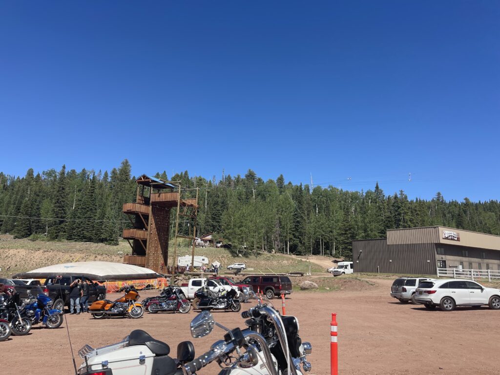
The rally is put on by the White Mountain Apache Tribe and is based out of their Hon-Dah Casino and Resort. I didn’t make up my mind to do this before the resort there filled up so I stayed at a hotel on the complete other side of the Show Low/Pinetop/Lakeside metropolitan area.
I had no idea what to expect as far as how busy it would be trying to check-in the morning of the event so I made sure to get there exactly when they said registration would open. I think the motorcycle crowd likes to sleep in because there was nobody around and lines were not a problem.
The signature event of the rally is the poker run. In a poker run you visit five stops and draw a playing card at each. At the end of the run the best hand wins the pot. I figured that the stops would just be around the Show Low/Pinetop/Lakeside area. What it ended up being was a 180-mile loop through the White Mountains of Arizona. With the route instructions was a deadline that you had to be back at the starting point by a certain time to turn in your “cards.” Not knowing how long this would take, I got packed up and headed out as soon as possible. Even when I left I still didn’t see that many riders showing up so I didn’t think that many people were participating.
The piece of paper given with the stops gave text instructions on how to get to each. That’s not really useful to a single rider because I can’t follow those without a lot of stopping. I just used the bike’s GPS instead and let it guide me (this almost got me in to trouble at one point in the ride).
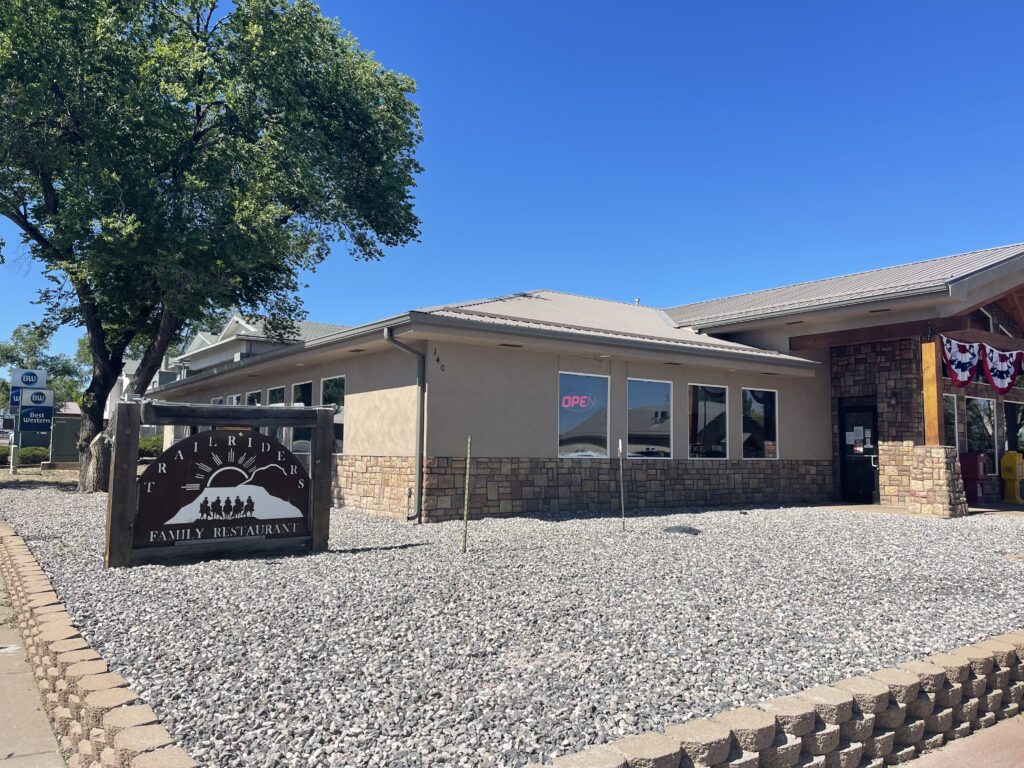
The first stop was pretty uneventful, Trailriders Family Restaurant and Bar in Eagar, Arizona. The “card drawing” was back in the bar. Obviously they don’t use real playing cards because they would need a lot of cards and people would likely find a way to cheat with their own cards. Instead you draw a small piece of paper with a number between 1 and 52 on it. They wrote the number drawn on the official card given for the even along with their own stamp for authenticity. The number obviously corresponds to a card in the standard playing card deck but you don’t know what the relation between the number and the card is until everything is turned in at the end of the ride (it did seem to be randomized and not in any kind of order). There was very little wait and I got my number was off to the next stop.
The route to the second stop is where I almost got myself in to trouble. The second stop was the tackle shop/gas station in Alpine, Arizona. It just so happened that Alpine had their Fourth of July parade at that time and the main highway through town was shut down for it. So hundreds of bikes and all of the other traffic trying to reach/go through Alpine were stopped on the highway approaching town because of the parade. The GPS on my bike saw the traffic problem building up for miles and suggested a little detour on some forest roads (in the end it wouldn’t matter much). My bike’s a dual sport (meaning it’s made to go off road) and I have tires that are suitable for off-road so it has no problem with dirt forest roads so I took the suggestion. It wasn’t until a few miles on these backwoods dirt roads that I realized my detour was not the smartest idea. For one, of course there’s no mobile phone service there in the middle of the forest. Secondly, no one knew where I was (especially since I was off the published poker run route) and I wasn’t riding with anyone. So if I fell and couldn’t get back up for some reason, I might have been there a while. I had the forethought to bring a Garmin inReach device that works all over the world in case of an emergency or just wanting to send a text message with no cellular service but left it back in my hotel room. The road got a little rough in places but I made it through. I still had to wait in the line with everyone else trying to get in to Alpine. The parade finally ended and the highway opened up again. Now there’s tons of bikers lined up parked all around and lined up at this tiny store trying to get their number drawn along with their normal customers and people trying to get gas. After at least an hour wait, I finally got my number and was off to the next stop.
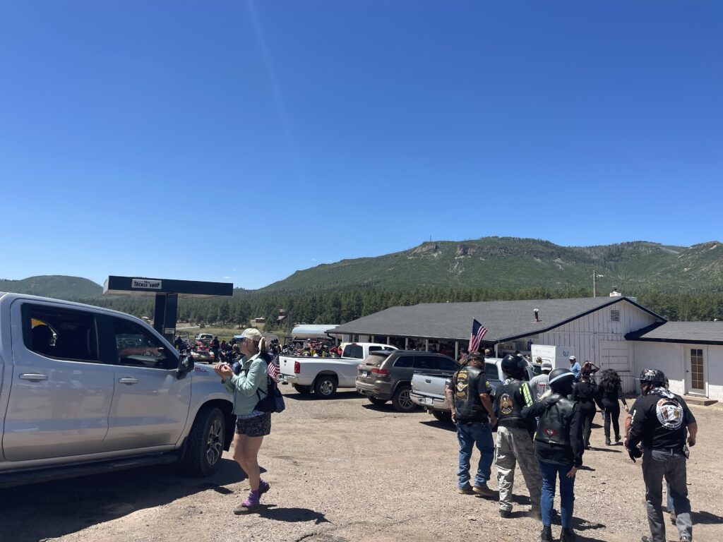
I was surprised that there were suddenly so many people at the second stop when there weren’t that many at the first one. I would think that I would see the same amount of people (more or less) at each stop if we’re following each other around the route. I guess some people run the route out of the order or backwards given and this would really become evident at the next stop especially since it was right around lunch time.
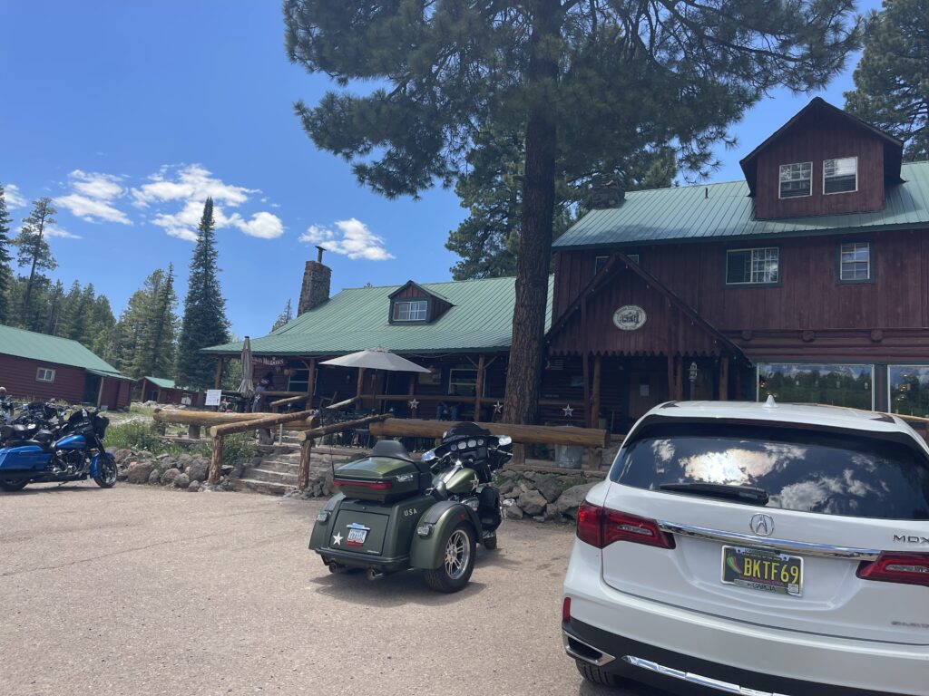
The third stop took me to the Hannagan Meadow Lodge in Hannagan Meadow, Arizona. There’s not much in Hannagan Meadow except the lodge. The lodge does have a restaurant but there’s no way they could deal with the amount of customers that arrived at that time. Instead they set up an outdoor grill and had burgers and pre-packaged chips available for purchase along with a large outdoor seating area to eat. I got my card drawn before getting some lunch and then it was on to the next stop.
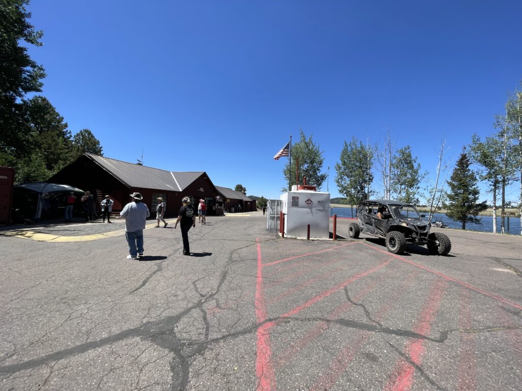
The fourth stop was in the vicinity of Big Lake. I thought Big Lake was at an elevation of 10,000 feet but the GPS says it’s 9,000 feet in elevation. There’s a general store there and the card drawing was in a tent just outside.
People from outside Arizona sometimes don’t realize that we have such varied elevations here (it’s not all just a flat desert, I think there are seven different climate zones in the state). Where I live is about 1,300 feet. I think the lowest point in the state is 800 feet (down by Yuma) and the highest is Mt. Humphries up by Flagstaff at over 12,000 feet. Throughout the poker run ride I went through 12,722 feet of elevation gain according to my GPS.
The final stop was at Sunrise Park Resort. Sunrise is a ski resort but it is open in the summer so there were already a lot of people there not participating in the motorcycle ride. They have zip lines, mountain biking, and they run at least one of the lifts so you can get to the top of the mountain. I didn’t have time for any of that so I got my card drawn and started back towards where it started. There were strict instructions that all cards had to be turned in by a certain time or they wouldn’t count.
From Sunrise Park Resort, it’s pretty much a straight shot back to the casino where we started on AZ-260, maybe about 15 miles. It had been a really long day of riding. About half way there the traffic on the highway comes to a complete stop in both directions. I was close enough to kind of see that there was an accident and that people were tending to someone. Soon an ambulance showed up and took one of them away. Not long after there was a sheriff wandering around in the field next to the highway. I guess she was looking for a suitable landing zone for a helicopter because the other person needed a trauma center and Pinetop/Lakeside doesn’t have that. The field wasn’t apparently level enough so they had to move a bunch of us off that highway on to a side road in order to use the highway as the helicopter’s landing zone.
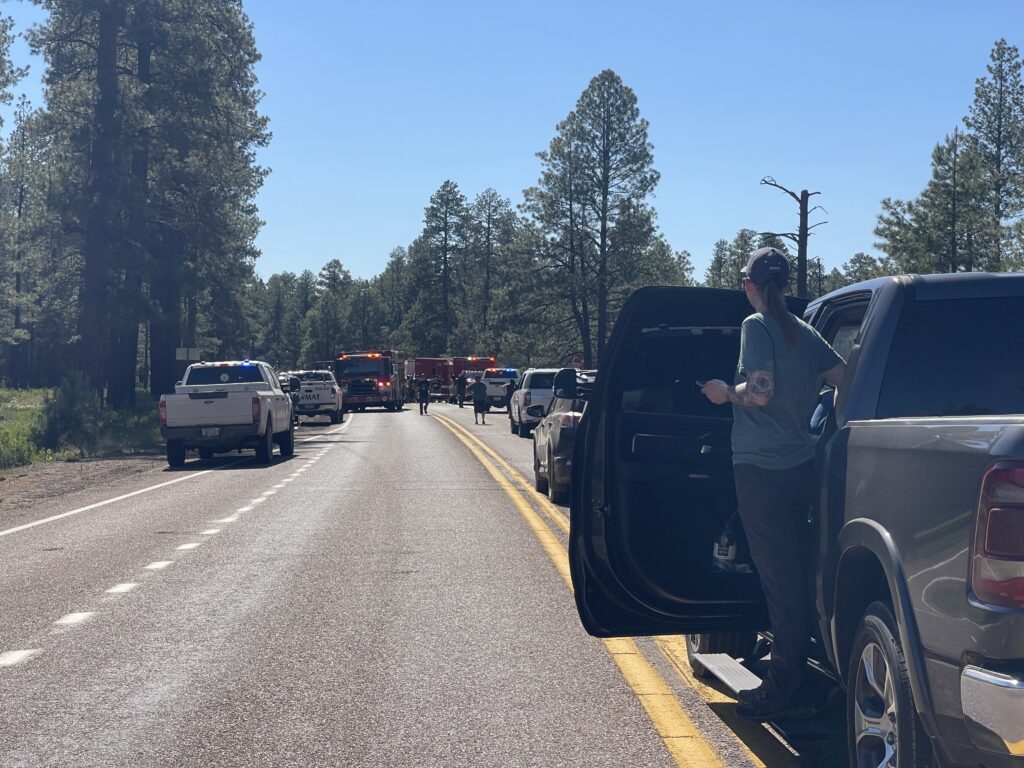
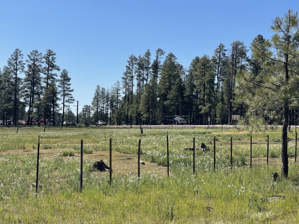
What I heard about what happened was that two bikes going in opposite directions had either collided head-on or clipped each other. I think one guy ended up beside the road and he was the one taken to a local hospital. The other guy left on the highway got the helicopter ride to either Flagstaff or Phoenix. I saw very few people on the ride wearing any kind of protective gear.
Even though a lot of us got back after the time deadline, they still accepted our cards. There really wasn’t any other way back so we were stuck. It was when I turned in my card with random numbers is when I saw what actual cards I got. I don’t remember what I had poker hand-wise but I do know that I didn’t have the highest hand nor the lowest hand (you could win money for the lowest hand too), so no prize money for me.
Included in the entry fee for the day’s activity was a steak dinner and all the soft drinks you could drink. The steak didn’t really sound appealing to me so I just hung around for a while. They had several show bikes there that people could vote on for various categories.
As I left the casino’s parking lot there were two wild horses just standing by the driveway going out to the main road.
The ride back home
The next morning I was to head back home. I decided to go back a different way than I came, so that meant going back west through Show Low and through Payson. Between Show Low and Payson is a road called the Desert to Tall Pines Scenic Road (also known as the Globe-Young Highway). I’ve been down this road once before in the truck and it’s not a bad road (it is technically a state highway, AZ-288). When it’s dirt it’s graded so easily doable on my bike. It switches from asphalt to dirt several times. However, it would have probably added a couple hours to my return trip and I was still tired from all of the riding the previous day so I decided to skip that and head towards Payson.
Coming down off the Mogollon Rim on AZ-260 is a pretty steep and winding grade. With my bike’s high engine compression, it made it so that I didn’t hardly have to touch the brakes. I had to make a stop in Payson if for no other reason to soak my cooling vest in water because the temperature was only going to get hotter the closer I got to Phoenix.